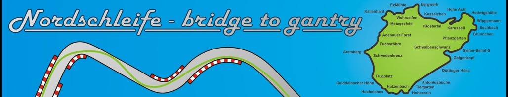
Route with names of the sections, kilometers and altitude:
| Route section: | Position: | Kilometer: | Altitude: |
| Driveway Antoniusbuche Tiergarten |
 |
km 0 to km 1 |
600 m 610 m 620 m |
| ● The new entrance for the tourist trips is on the Döttinger Höhe. ● Antoniusbuche: Until 1935, a huge beech tree stood to the left of the track. An altar dedicated to St. Anthony is said to have stood beneath it. The Antoniusbrücke is also located on this section of the route. ● The Tiergarten (Zoo) used to be a burial ground for animals that died in the war. |
|||
Hohenrain T13 |
 |
km 1 to km 2 |
620 m |
| ● Hohenrain runs along a high meadow or field boundary, which is where this ancient name comes from. ● T13 is the designation for one of the old grandstand facilities. The former start with the pits is located here. It is also the highest point of the Nordschleife. |
|||
Hatzenbach |
 |
km 2 to km 3 |
620 m 585 m 560 m |
| ● Hatzenbach: In this section, the stream of the same name runs alongside the track. |
|||
| Hocheichen Quiddelbacher Höhe |
 |
km 3 to km 4 |
560 m 580 m 550 m |
| ● Hocheichen: There used to be dense oak forests here. Some of them had to be cut down to build the line. ● The Quiddelbacher Höhe runs along a ridge near the village of Quiddelbach. |
|||
Flugplatz Kottenborn |
 |
km 4 to km 5 |
550 m 570 m 535 m |
| ● There was a former gliding area to the left of the race track at the Flugplatz (Airfield). ● The name Kottenborn is no longer used today. It comes from the village of the same name, which lies to the left of the track. |
|||
| Schwedenkreuz Aremberg Postbrücke |
 |
km 5 to km 6 |
535 m 460 m 470 m |
| ● In 1638, the then mayor of Kehlberg was slain by Swedish soldiers. The Schwedenkreuz (Swedish Cross) erected on this occasion still stands today. ● Aremberg: The village of Aremberg and the mountain of the same name are located near this section of the track. ● The name Postbrücke (Post Bridge) (or Poststraße (Post Street)) is no longer commonly used today. The name comes from the post road that runs along the track here and then crosses it with a bridge. |
|||
| Fuchsröhre Kompression Adenauer Forst |
 |
km 6 to km 7 |
470 m 480 m 470 m |
| ● Fuchsröhre (Fox Tube): During track construction, a startled fox had crawled into a drainage pipe. The depression at the end of the Fuchsröhre is often referred to as a compression. ● The Adenauer Forst (Adenauer Forest) leads through a forest area in the municipality of Adenau. |
|||
Metzgesfeld |
 |
km 7 to km 8 |
470 m 460 m 410 m |
| ● The name Metzgesfeld comes from the land register’s designation of the same name. |
|||
| Kallenhard Spiegelkurve Dreifach-Rechts |
 |
km 8 to km 9 |
410 m 380 m 350 m |
| ● The name for the Kallenhard section is derived from the overgrowth of the area. The tree-covered slope was called Hart. The hilltop was rather bare with shrubs only. ● Unofficially there is the term Spiegelkurve (Mirror Curve). At this bend, drivers regularly drove off their rear-view mirrors on the hedges that used to stand there. ● The Dreifach-Rechts (Triple Right) is a combination of three consecutive right-hand bends. These can be taken together with one steering angle. However, you only drive right up to the kerbs on the middle section of the bend. In the first and last sections of the bend, however, you leave a little distance to the kerbs on the inside of the bend. This is why this bend is also known as the miss-hit-miss. |
|||
| Wehrseifen ExMühle Breidscheid |
 |
km 9 to km 10 |
350 m 320 m 370 m |
| ● Wehrseifen: In the valley (Celtic: Seifen) there used to be a training ground for the militia. ● The ExMühle is named after a mill that stood outside (Latin: Ex) Adenau. ● Breidscheid is not an official name for a section of the route. The Nordschleife runs through the village of the same name. This is the lowest point of the Nordschleife. There is also another access road here. |
|||
| ExTal Bergwerk |
 |
km 10 to km 11 |
370 m 380 m 395 m |
| ● The section between the ExMühle and the mine used to be known as ExTal. ● Bergwerk (Mine): Until the beginning of the 20th century, there was a mine here where lead and silver were mined. |
|||
Kesselchen |
 |
km 11 to km 12 |
395 m 420 m 480 m |
| ● Kesselchen: Here the route leads through a basin. |
|||
| Mutkurve Klostertal |
 |
km 12 to km 13 |
480 m 510 m 525 m |
| ● Only the bravest drivers take this bend to the full. This is where the unofficial name Mutkurve (Courage Curve) comes from. ● There was an Order of St. John in the Klostertal (Monastery Valley) in the 14th century. Later, a monk lived here as a hermit. |
|||
| Klostertalkuve Steilstrecke Caracciola-Karussell |
 |
km 13 to km 14 |
525 m 560 m 580 m |
| ● The Klostertalkurve (Monastery Valley Curve) is the junction to the steep section. ● The Steilstrecke (Steep Section) with a gradient of up to 27% was originally built for vehicle tests. It is no longer used today. ● The Karussell (Carousel) with its steep bend was named after the racing driver Rudolf Caricciola. He was the first to drive the curve completely inside. |
|||
| Posten 147 Hohe Acht |
 |
km 14 to km 15 |
580 m 620 m 590 m |
| ● Posten 147 (Post 147) is a small hut (also known as an Alm (alpine pasture)) in a bend between the roundabout and the Hohe Acht (High Eight). ● The Hohe Acht (High Eight) leads past the mountain of the same name. At 747 m, it is the highest mountain in the Eifel. The Hohe Acht is the second highest point on the Nordschleife after the section at T13. |
|||
| Hedwigshöhe Wippermann Eschbach |
 |
km 15 to km 16 |
590 m 580 m 540 m |
| ● Hedwigshöhe is named after Hedwig Creutz, the wife of the forefather of the Nürburgring. She enjoyed the view from the hill during the construction work. ● The Wippermann gets its name from the bobbing up and down of the vehicles in this area. In the meantime, the severe bumps in this section have been mitigated. ● Eschbach is named after the stream of the same name and the village of Herresbach-Eschbach. There used to be many ash trees here. |
|||
| Brünnchen Eiskurve Pflanzgarten |
 |
km 16 to km 17 |
540 m 535 m 530 m |
| ● The Brünnchen (Well) leads through a spring area from which the municipality of Herschbroich used to draw its water. ● The Eiskurve (Ice Curve) got its name because the track becomes particularly slippery here in bad weather. ● The gardens and fields of the Counts of Nürburg were located at Pflanzgarten (Plant Garden). |
|||
| kleiner Sprunghügel großer Sprunghügel Stefan-Bellof-S (Pflanzgarten II) |
 |
km 17 to km 18 |
530 m 525 m 550 m |
| ● The Pflanzgarten (Plant Garden)and Pflanzgarten II sections are home to the kleiner Sprunghügel (Small Jumping Hill) and großer Sprunghügel (Large Jumping Hill). ● Pflanzgarten II was officially renamed Stefan-Bellof-S in 2013. Stefan Bellof drove the Nordschleife in a Porsche 956 in 1983 in a record time of 6 minutes 11.13 seconds. This record time remains unbeaten to this day. |
|||
Schwalbenschwanz kleines Karussell |
 |
km 18 to km 19 |
550 m 565 m 560 m |
| ● The Schwalbenschwanz (Swallowtail) gets its name from the course of the route. From a bird’s eye view, it is reminiscent of the shape of a swallow’s tail. ● The kleines Karusell (Small Carousel) is a smaller steep concrete curve that leads from Schwalbenschwanz to Galgenkopf (Gallows Head). |
|||
Galgenkopf |
 |
km 19 to km 20 |
560 m 550 m 555 m |
| ● The former place of execution of the Counts of Nürburg with a public gallows was located at the Galgenkopf (Gallows Head). |
|||
Döttinger Höhe |
 |
km 20 to km 20,8 |
555 m 565 m 600 m |
| ● The Döttinger Höhe is named after the nearby village of Döttingen. |
|||
All kilometers refer to the entrance for tourist trips.
All altitudes refer to the approximate average altitude in the respective section of the route.